Today was really wonderful. It was warm with a clear blue sky as I drove across the Kansas prairie. I followed close to or on top of the old Santa Fe Trail the entire day. My first stop was the Santa Fe Trail Museum just outside Larned, Kansas. The museum is put together by the local historical society and is very good. It contains artifacts from the period when the trail was one of the main east-west routes as well as the later period of settlement of Larned. I never knew that most of the merchants along the trail were Mexicans. The border between Spanish Mexico and the American territory was the Arkansas River that flows near Larned. The Spanish would not allow Mexicans to participate in trade or mercantile activities, but after Mexico became independent in 1821 all that changed and the Mexicans in Santa Fe began to engage in trade with the American frontier and eventually handled much of the trade along the trail.
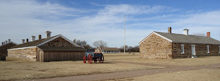
My second stop was the Fort Larned National Historic Site. I was the only visitor during my one hour there. The fort was used by the US military to protect the Santa Fe Trail and its travellers from raids by the plains indians who were upset by the encroachment of the Anglos. The barracks, hospital, commissary, and officers quarters are all open and are furnished much as they would have been in the 1860s. Anyone driving through Kansas ought to make this a stop. It's exhibits of military life along the trail were also good.
I discovered later in the day that the Arkansas River actually was dry as a bone:. no water, only 4-wheeler tracks in the sand. It must be something of an "arroyo" or "wadi" here, dry except after big rains. Why is there a good Spanish word and a good Arabic word, but no English word for such a seasonal river? If you think about it, the answer will come to you.
The grasslands between Larned and Dodge City are beautiful. I have always enjoyed beautiful mountain scenes and beautiful ocean scenes. I had never thought that a grassland might be just as beautiful. It is, but in its own way. Here is a 360 degree video taken from Pawnee Rock.
There was one place along the road where you could still see some of the wagon tracks made along the Santa Fe Trail. The wagons typically went four abreast in order to avoid following in each other's dust. Thus, there may be as many as eight wagon wheel ruts, although few survive visibly now 150 years later. Here is onewhere there was a historical marker a short walking distance off the road.
Dodge City tries to live off its history as a "wild west' town. The main street with all the fast food restaurants and motels is "Wyatt Earp Boulevard." I wasn't impressed. It did not have a genuine feel. (After getting some gas, I "got out of Dodge," which is, by the way, where that saying comes from.
I drove along US Route 50 through a lot more grassland on my way to the Colorado border and then to Lamar. At one point I did have to veer to avoid tumbleweed heading down the road toward me. At times there was pure grassland, at other times the landscape was filled with sagebrush.
This part of Kansas is cattle country, much of it Black Angus. Along route 50 near Holcomb (the town of the "In Cold Blood" killings described by Truman Capote) I passed a Tyson plant that is said to be the world's largest meat packing plant. Nearby were quite a few cattle yards with thousands of cattle waiting for their turn. Large trains with dozens and dozens of freight and tank cars were pulled up to the plant.


This sounds like a very interesting day! Dave Y
ReplyDeleteSounds like your great adventure continues with yet another change of scenery. Prarie grass and sagebrush on the old Santa Fe Trail...I like the imagery.
ReplyDelete